Winter Weather on the Way to Colorado Ski Towns

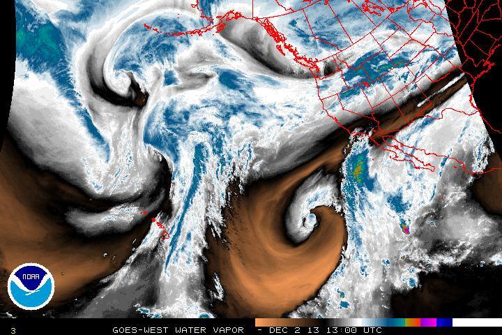
Snow! Yes, Colorado Ski Towns rejoice! A winter storm will make its presence known later in the day and will last a while. Very favorable weather conditions are setting up for a prolong snow and wind event. The water vapor shot shows the outline of a west to east jet stream that will sag down slowly over the state. Energy, high winds, plenty of moisture and right orientation for wind direction will make this storm hard to miss us. West facing slopes are going to see the most in the I-70 corridor and further south. Summit County could see an impressive snowfall in the amount of 6-12″ if not more ( 1-3 ft) for favored slopes.
While we are all excited be aware, snowpack can not support what is about to happen. Just a few hours of wind last night closed Loveland Pass due to an avalanche and that was without any new snow! We will see winds exceeding hurricane force along the divide with heavy snow lasting for hours. This will bury a weak faceted snowpack and with the wind move the stress load of shear weight down slope. Natural avalanching will be the problem by Wednesday. Round 2 of the storm will be brutally cold temps that will keep the snowpack from stabilizing. What hazard forms will remain for a long time and also reactivate buried persistent slabs that were formed Nov 25 from the last wind event.
Folks it is about to get very “real” so avoid it all and wait and see how it all develops! When Joe Ramey from the GJ weather office writes a book on the developing storm you know its a good one! And yes Suzy I strapped my bar-b-que grill cover down well as it is going to get interesting!!!
~Dan Moroz
MtnTownViews.com is MTN Town Magazine‘s daily journal blogging about Colorado’s mountain towns and resorts. Like them on Facebook and Follow on Twitter. Click the cover to read the Winter 2012-13 Issue.
© 2013 MTN Town Magazine. All rights reserved. Republication, in part or entirety, requires permission.


